
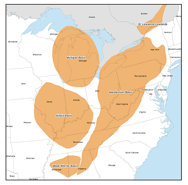
Eastern US / Appalachian Basin Geological Edge Set
GeoEdges Inc. provides detailed and accurate subsurface geology at your fingertips in ArcGIS, GeoGraphix, Petra and all other ESRI Shapefile compatible mapping applications. Includes geological edges for New York, Ohio, Pennsylvania, Kentucky, Tennessee, West Virginia, Virginia, Michigan, Ontario and Quebec; coverage in the Appalachian, Illinois, Michigan, and Black Warrior Basins and the St. Lawrence Lowlands. Includes field outlines, structural features, formation limits and outcrops, reservoir trends, structure and isopach maps, shale gas trends
2024 Pricing
Annual License Subscription
The Eastern U.S. / Appalachian Basin Geological Edge Set is available to subscribing companies on an annual license basis (per company, based on daily production):
>100,000 BOE/d USD $19,000 per year
<100,000 BOE/d USD $17,100 per year (discounted 10%)
<60,000 BOE/d USD $15,200 per year (discounted 20%)
<20,000 BOE/d USD $12,350 per year (discounted 35%)
<10,000 BOE/d USD $9,500 per year (discounted 50%)
<2,000 BOE/d USD $6,650 per year (discounted 65%)Note 1: for gas production please use a 6:1 conversion to BOE (1 BOE = 6 mcf)
Note 2: A service company's annual license fee will be based on the revenue of the company and not on production
Note 3: North American Shales is discounted 15% for each other set that a company licenses (due to geographic overlap)
LICENSE FEE INCLUDES:
Full set of ESRI Shape files compatible with most mapping applications (Petra, GeoGraphix, etc.)
Petra Thematic Mapper Projects, GeoGraphix Projects, ArcGIS Projects
Hard copy prints of key maps
Regional cross-sections in PDF format
Digital user's manual
Access to ongoing updates and additions to mapping, technical support
Coverage for New York, Pennsylvania, West Virginia, Virginia, Tennessee, Kentucky, Ohio, Illinois, Indiana, Michigan, and Ontario
LIST OF GEOLOGICAL FEATURES PROVIDED:
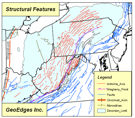
General Features: Appalachian Basin outline, faults, anticline and syncline axes, arches, Allegheny Front, Cincinnati Arch, Pine Mtn Thrust, state and county boundaries, provinicial boundaries
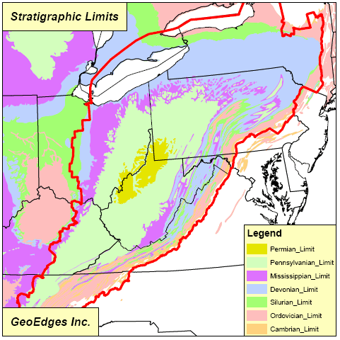
Stratigraphic Limits: Cambrian, Ordovician, Silurian, Devonian, Mississippian, Pennsylvanian, Permian
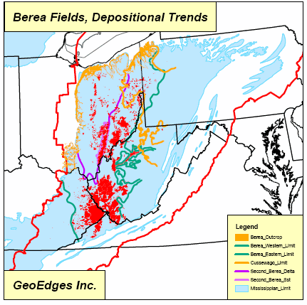
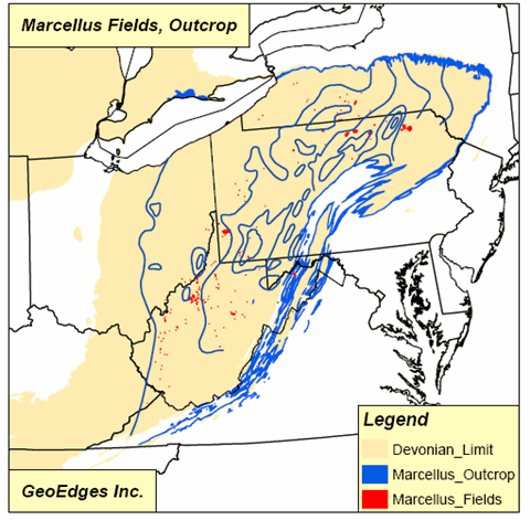
Outcrops: Cambrian, Ordovician, Silurian, Devonian, Mississippian, Pennsylvanian, Permian, Marcellus, Ohio, Tully, Berea, Venango, etc
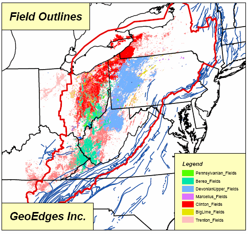
Oil & Gas Fields: Cambrian Fields, Ordovician Fields, Silurian Fields, Lower Devonian Big Lime Fields, Upper Devonian Fields, Devonian Shale Fields, MissDev Berea Fields, Pennsylvanian Fields, Antrim Fields, New Albany Fields, Marcellus Fields, Conasauga Fields, Floyd-Neal Fields
Mississippian: Berea Limits and isopach, Big Injun, Weir, Floyd-Neal
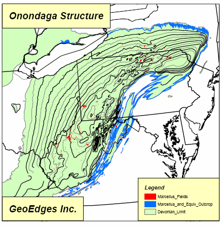
Devonian Shales: Marcellus, Geneseo, Rhinestreet, Huron, Cleveland and Sonyea radioactive shale isopachs, western limit of Marcellus shale, Onondaga structure
Devonian: Berea sst isopach, Berea formation limits, Second Berea, Second Berea delta, Venango isopach, Venango cycle limits, Bradford isopach, Bradford cycle limits, Elk isopach, Benson sst isopach, Onondaga, Upper Benson turbidites
Silurian: Grimsby sst isopach, Whirlpool sst isopach, Lower Silurian isopach, Niagaran platform and patch reefs, Tuscarora facies, Medina / Tuscarora play areas
Ordovician: Collingwood, Trenton, Utica
Precambrian: Precambrian structure