
Australia Geological Edge Set
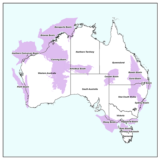
GeoEdges Inc. provides detailed and accurate subsurface geology at your fingertips in ArcGIS, Petrosys, GeoGraphix, Petra and all other ESRI Shapefile compatible mapping applications. Includes geological edges for Amadeus, Browse, Bonaparte, Bowen, Canning, Cooper, Gippsland, Maryborough, Otway, Perth, and Surat Basins. Includes field outlines, structural features, basins, sub-basins, outcrops, subcrops, reservoir trends, structure and isopach maps, shale gas trends, oil and gas windows, geo-referenced tiffs, basin stratigraphy, and cross-sections.
2024 Pricing
Annual License Subscription
The Australia Geological Edge Set is available to subscribing companies on an annual license basis (per company, based on daily worldwide production):
>100,000 BOE/d USD $19,000 per year
<100,000 BOE/d USD $17,100 per year (discounted 10%)
<60,000 BOE/d USD $15,200 per year (discounted 20%)
<20,000 BOE/d USD $12,350 per year (discounted 35%)
<10,000 BOE/d USD $9,500 per year (discounted 50%)
<2,000 BOE/d USD $6,650 per year (discounted 65%)Note 1: for gas production please use a 6:1 conversion to BOE (1 BOE = 6 mcf)
Note 2: A service company's annual license fee will be based on the revenue of the company and not on production
Note 3: North American Shales is discounted 15% for each other set that a company licenses (due to geographic overlap)
LICENSE FEE INCLUDES:
Full set of ESRI Shape files compatible with most mapping applications (Petrosys, Petra, GeoGraphix, etc.)
ArcGIS map and layer files for import into Petrosys and ArcMAP
Petra Thematic Mapper Projects, GeoGraphix Projects
Hard copy prints of key maps
Regional cross-sections in PDF format
Digital user's manual
Access to ongoing updates and additions to mapping, technical support
Coverage for onshore and offshore Australia
LIST OF GEOLOGICAL FEATURES PROVIDED:
General Features: Faults, Anticlines, Basin Axes, Basins, States, Pipelines and Transportation Culture, Cross-section locations
Bedrock Geology: Tertiary, Cretaceous, Jurassic, Permian, Carboniferous, Devonian, Silurian, Ordovician, Cambrian, Precambrian
O & G Fields: Oil, Gas, Coal Seam Gas, Shale Gas, Tertiary, Cretaceous, Jurassic, Triassic, Permian, Carboniferous, Devonian, Ordovician
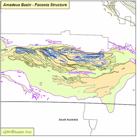
Amadeus Basin: Pacoota Structure, Ordovician Limit, Horn Valley Isopach and Maturity, Horn Valley Limit
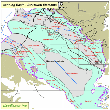
Canning Basin: Sub-basins, Structural Elements, Shale Prospective Areas
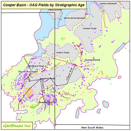
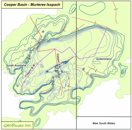
Cooper Basin: Permian and Triassic Limits, Sub-basins, Daralingie, Epsilon and Patchawarra Subcrops, Murteree Isopach, Structure, Subcrop, Wet & Dry Gas Windows, Roseneath Isopach and Subcrop, Geo-referenced Structural tiffs
NW Shelf: Bonaparte, Browse, Carnarvon Sub-basins and Structural Elements
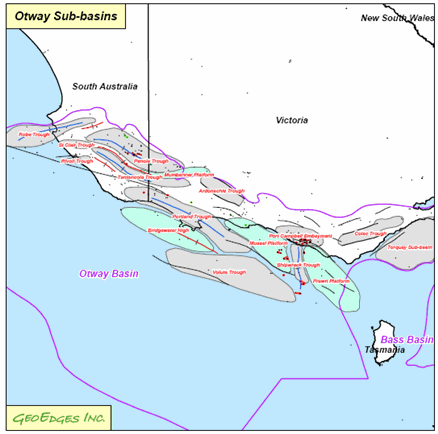
Otway/Gippsland: Casterton Top Structure and Maturity, Otway and Gippsland Sub-basins, Structural Elements
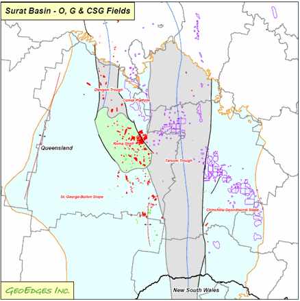
Surat/Bowen: Sub-basins, Evergreen Limit and Structure, Precipice Sandstone Limit and Structure, Rewan Sandstone Limit and Structure, Showgrounds Sandstone Limit and Structure, Snake Creek Shale Limit